


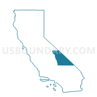
Voting District 50125, Inyo County, California
About
Outline

Summary
| Unique Area Identifier | 531131 |
| Name | Voting District 50125 |
| County | Inyo County |
| State | California |
| Area (square miles) | 104.28 |
| Land Area (square miles) | 104.11 |
| Water Area (square miles) | 0.17 |
| % of Land Area | 99.83 |
| % of Water Area | 0.17 |
| Latitude of the Internal Point | 35.88123200 |
| Longtitude of the Internal Point | -117.34371450 |
Maps


Graphs
Select a template below for downloading or customizing gragh for Voting District 50125, Inyo County, California


Neighbors
Neighoring Voting District (by Name) Neighboring Voting District on the Map
- Voting District 10275, San Bernardino County, CA
- Voting District 10285, San Bernardino County, CA
- Voting District 10480, San Bernardino County, CA
- Voting District 50120, Inyo County, CA
- Voting District 50126, Inyo County, CA
Top 10 Neighboring County Subdivision (by Population) Neighboring County Subdivision on the Map
Top 10 Neighboring Place (by Population) Neighboring Place on the Map
- Searles Valley CDP, CA (1,739)
- Homewood Canyon CDP, CA (44)
- Trona CDP, CA (18)
- Valley Wells CDP, CA (0)
Top 10 Neighboring Unified School District (by Population) Neighboring Unified School District on the Map
- Sierra Sands Unified School District, CA (35,267)
- Lone Pine Unified School District, CA (2,549)
- Trona Joint Unified School District, CA (1,885)
- Death Valley Unified School District, CA (765)